Juneau to Anchorage on Alaska Airlines

I have such mixed feelings towards Alaska Airlines. I am about to vent, so if venting bores you, just skip down to the pictures.
I love that Alaska Airlines is truly Alaskan, formed of a conglomeration of smaller companies that used to fly Alaska, and that they truly serve Alaskans well. Alaskans get all kinds of perks on Alaskan airline. So when they board, it’s like “these special people, and then these special people, and these special people, and all the rest of you” and like there are six of us not-so-special people still standing there waiting to get on. After my first flight with Alaska, I learned not to carry any carry on baggage; just a large handbag I can tuck under the seat in front of me; all the overhead compartments are full.
Yes. I know. It sounds like sour grapes, and it is a little bit. I’ve been special too, on other airlines, and you get so you kind of like being treated special. I just take a deep breath and tell myself that old saw “every monkey gets his turn in the barrel” which is sort of a karma thing, everybody gets lucky some time and other times everyone has to take a turn in the barrel.
Here’s where the grapes really got sour. I am a cherry picker when it comes to trip planning. I don’t always get it right, but I put a lot of planning into finding the right small tours, the right schedule, the right seats, the right accommodations. I love the special details, and I take pride in juggling all the factors and getting a strategic plan together.
I found the perfect reservations, reservations that got us from Pensacola to Juneau in one day, and then from Anchorage back to Pensacola in one day. For three months, I gloried in the perfection of those reservations, until Chelsea called me and said they had changed everything.
It was horrible. I had to make decisions I wasn’t prepared to make. Chelsea did her best, but I was no longer in control (OH NO!) and I just did the best I could. She really did work with me. I was mad about the circumstances, but she did her best to find a solution. Just about every change cost me money, including the worst of all, because I am not special on Alaskan Airlines or American Airlines, we had to pay $25 every time we checked a bag, and every time we had a (mandatory) overnight, we had to pick up our bags and PAY AGAIN THE NEXT DAY! It irked me because I had us starting off with Delta originally, where our bags go free. Hey, these $50 (for two people) charges add up fast!
Of course, any seasoned traveller will laugh at “perfect” travel plans. It is a set-up. There is no perfect; God-with-a-sense-of-humor will always humble our human arrogance when we think we have achieved perfection.
So you know our trip started badly with the continuing weather delays in Dallas Fort Worth, and that was not American Airlines fault, but even so, neither was it a fun way to start our vacation.
Now, leaving Juneau for Anchorage, it’s a piece of cake. The hotel is five minutes from the airport and car rental drop-off is just out the back door. Juneau airport is small, and friendly feeling. The Alaska Airlines baggage check-in was compassionate. She looked at our trip history so far and said “you guys don’t have to pay today” and that small gesture really made us feel good.
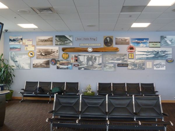
At our gate, I took a photo of the entire upstairs waiting room. This is the whole Juneau airport:

At our gate is a pictorial history of Alaska aviation, but it doesn’t answer my question: What was the other airline that flew alongside Coastal Airlines out of the downtown amphibious airport?
The plane we are on is kind of old-timey, and it is stopping in Yakutat and Cordova, two fishing villages, en route to Anchorage. There is no first class on this flight, but there is freight, and evidently a whole lot of freight. I have never seen this before, but the front part of the airplane is all blocked off with this black curtain/built-in thing for freight:

Sitting next to me is a man exactly my age who grew up across the channel from me. We were the same year in school, and he is cousin to the girls I played with when I was a kid. We didn’t know each other. As a grown-up, he piloted ferries for the Alaskan Marine Highway System and now does special contracts, guiding the large cruise ships through the various ice fields. And, he tells me, the other airline flying out of Juneau when we were kids, the one with the green planes, is Ellis Airlines. Wooo HOOOO! He tells me before we take off so I quickly text my Mom’s old friend because she was stumped, too! I knew it started with an “S”, LOL. Isn’t life funny, how you can end up sitting next to the right person at the right time and place, and ask the right question?
Anchorage airport is much larger than Juneau, but as we pick up our rental car, the man behind the counter learns we are former military and gives us a great car, and map, and lots of good directions to get us headed towards Seward. Life is sweet, in spite of all my griping and sour grapes.
Where is Lokoja, Nigeria?
Today the church celebrates the Birth of John the Baptist, whom the Moslems call Yahyah, and who has a much-visited tomb in the Ummayyad Mosque in Damascus, Syria. The church also prays today for the diocese of Lokoja, Nigeria, which is just south of Abuja, from where 300 girls were kidnapped by Boko Haram, people who believe girls should not be educated. Most of those girls are still missing. Three hundred girls . . . Lokoja . . . John the Baptist . . . Syria . . . so much need for prayer. . . The reading is from Forward Day by Day.

TUESDAY, June 24 The Nativity of Saint John the Baptist
Isaiah 40:11. He will feed his flock like a shepherd; he will gather the lambs in his arms, and carry them in his bosom, and gently lead the mother sheep.
So much of our scripture is violent and distressing, yet there are many passages like this, full of comfort and assurance that the trouble is over. Others might look at it and say, “Your God is violent and terrible, and the reassurances are flat and silly.”
Maybe that’s true. I tend to look at them more as descriptions of how we experience our lives rather than declarations of God’s nature. Our lives are difficult and often catastrophic—earthquakes, malaria, civil wars, and dangerous militias, to name only a few issues—and our lack of control means we blame God for it. But I don’t think God acts that way. And in the face of catastrophe, we say meaningless things: “Everything happens for a reason.” That’s no comfort at all.
Isaiah speaks peace to his people, trying his hardest to take their pain seriously and to offer the truth that everything will be okay in the end. When it’s not okay, it’s not yet the end. That “okayness” might be justice here or it might be eternal life, but this present trouble is not the end of the story.
PRAY for the Diocese of Doko (Lokoja, Nigeria)
Today the Church remembers The Nativity of Saint John the Baptist.
Ps 85 or 85:7-13; Isaiah 40:1-11; Acts 13:14b-26; Luke 1:57-80
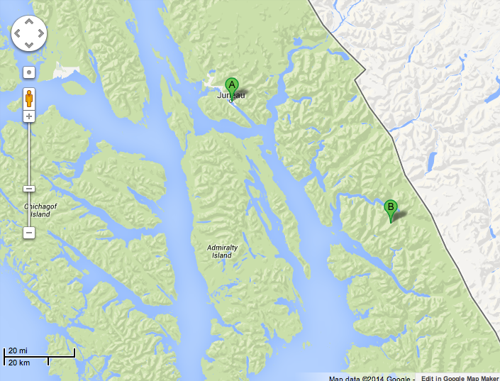
From Juneau to Tracy Arms Fjord on AdventureBound
Taking a break from The Celebration, we get up early, drive to our Juneau friend’s house and park our car and she drives us over and drops us off to catch the AdventureBound trip out to Tracy Arms. For two weeks the weather forecasts have told us that this day will be sunny, bright and warm, and ha ha ha on us, it is cloudy and cold, but not much rain. In Juneau, not much rain is a pretty good day :-).
We meet some really fun people as we wait to board – one couple married four days, one couple of young adventurers who, like us, travel on their own as opposed to group travel or cruise ship travel. Our lively conversation made us late to board, only to discover that everyone else had booked for this “sunny” day and every seat in the cabin would be occupied. Once you sit down, that is YOUR spot, oh ugh, this is the worst kind of tour for us, but we discover we can go in and out at will and this works. We spend a lot of time outside, taking photos, watching for whale and porpoise and bear and eagles – all kinds of wildlife. It’s not so bad.
Before we leave, I shoot this photo. It’s not original; I had a similar poster once from the 1920’s or 1930’s advertising trans-Atlantic boat travel on some French line. I just love the lines:

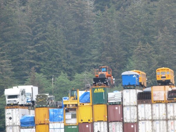
Juneau is landlocked, so everything that comes in or goes out goes by boat or plane. Container barges bring in larger items, and I was amazed how high they can stack a barge. I was also amazed that on top of the containers are vehicles strapped on tight; school buses, campers, snow plows – no wonder everything costs so much more in Alaska!

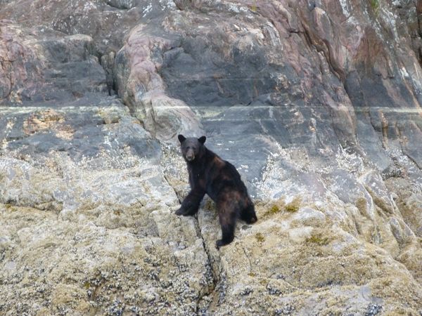
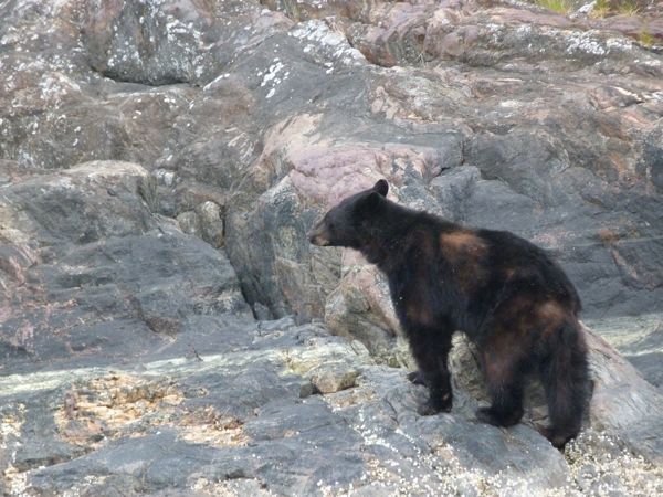
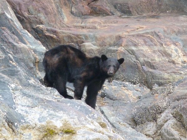
These bear made me so sad. Look how skinny they are, down at the bottom of tall, steep cliffs, eating barnacles. Bear eating barnacles – they must be starving. Some of them look all molty and have fur coming off.
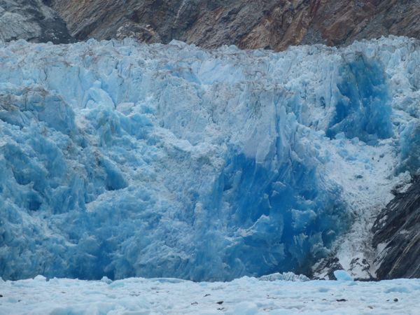
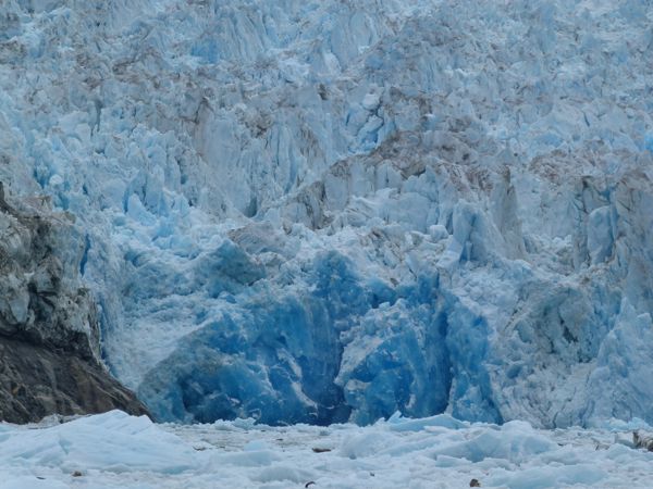
I never saw these glaciers when I was little. The Mendenhall glacier is relatively large compared to the Sawyer glaciers (1) and (2) but the Sawyer glaciers are calving. The sound is unforgettable, the cracking, the thunder, and entire sections of the glacier falling into the bay. Other burgs crack off underwater, and they come up huge, whole and a sparkling, unforgettable icy deep blue:
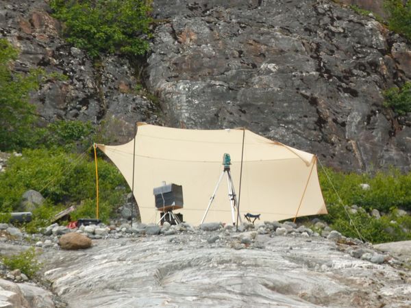
There is equipment going all the time at Tracy Arms to record the calving, the sights and sounds:
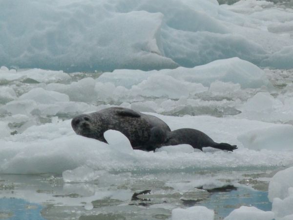
Mama and baby seals catching a few rays at high noon near the glacier:
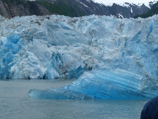


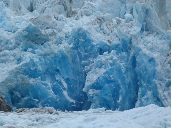
Here is a piece breaking and falling into the water:


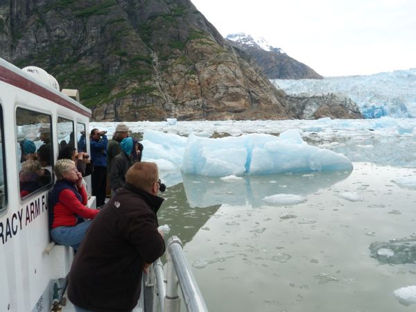
You can see the tour boat is surrounded by ice and icebergs:
The glaciers are currently neither advancing nor receding, but you can read the trail of the glacier’s recession over thousands of years in the steep, ice-scraped mountains on both sides:

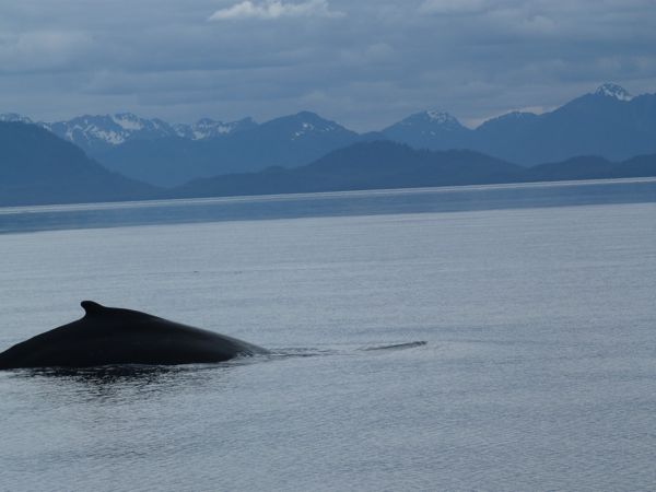
On our way home, we spot whale. You can shoot a lot of shots of a piece of whale, or where the whale was a split-second ago, LOL.

As we reach the dock, I call our friend to tell her we are arriving and she laughs and tells me she is already on her way; she was watching the boat arrive from her place across the channel. Within minutes, she is picking us up for home made fish cakes and chop chop salad. Best of all, great conversation, lots of laughter and wonderful stories of past times in Alaska. Her family was a pioneer family in Nome before she married and came to Juneau, so she has some great tales to share. Our families have had a lot of joint adventures, in Alaska, in Germany and in Edmonds.
She also asks great questions like “how did you buy groceries in Kuwait?” and “what did you do about laundry?”, practical questions, and exactly the kinds of things that made our lives more challenging – and interesting – to us. It was a great evening.
Name that Country: A Most Difficult Challenge
This morning, as I was praying for Panama – there is always a diocese listed in the daily lectionary to be prayed for somewhere in the world – I was thinking how I know where Panama is. When we are praying for Nigeria, there are names I haven’t heard of. I now Lagos, and Port Harcourt, but where is Abuja? Owerri? I go to GoogleEarth and look them up.
I struggle with how little the average American knows about geographical location. It’s just embarrassing. Through all the years I lived abroad, most of the time, unless it was Germany, people couldn’t quite place where I was living. Many had heard of Tunisia; we had troops there in World War II, and Saudi Arabia, because they had seen it often enough on the news, but the rest of the Arab Gulf, Jordan, Syria, North Africa – beyond them.
Then, on the first night of one of my grad classes, the professor handed us this map and gave us ten minutes to put in the appropriate country names. He did not, thanks be to God, ask us to put in capitals. Not a single one of us got them all, and this was a class full of nation-oriented people.
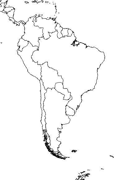
It was also on the final exam, three months later, and most of us got them all right – thanks to some fervent cramming and study groups.
Here are a couple more maps, in case you are feeling cocky. See if you can accurately fill in the name of each country:
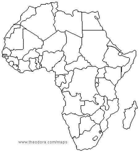

Bonne chance!
Galilee Cafe, Mobile, and Foley AL; Life in Small Adventures
AdventureMan was perusing the Weekend Section of the Pensacola News Journal when he saw the opening of the Farmer’s Market in Foley, AL, and he said “Let’s go!”
“Let’s Go!” and my agreement doesn’t always mean we will really go. The market isn’t until 3 in the afternoon, and a lot can happen. Sometimes we just change our minds.
But at water aerobics, I get a great idea, and I can hardly wait to share it with AdventureMan.
“Let’s go to the Jordan River Cafe for their Friday buffet, then head down toward Foley through Fairhope!” He loves the idea, we run a couple errands on the way home, I call the restaurant to make sure they are still open (It’s been about a year since we last went there) and then hit the road for Mobile:

When we get to the restaurant, we discover it is no longer the Jordan River Cafe; it is now the Galilee Cafe, and I wonder if the food will still be so good as before. As we enter, we are shocked – the Cafe is PACKED. Every table is taken – no, no, there is one small table, over in the back, we can have that one, the welcoming waitress says.
Galilee Cafe
326 Azalea
Mobile
T: 251-304-0297

Lunch was fantastic. Yes, the restaurant has changed hands; the current owner born in Bethlehem, and we are astonished and delighted to see so many people enjoying “Mediterranean” cuisine, which is suspiciously like what we used to eat in Jordan and Syria 🙂 The restaurant stayed busy the entire time we were there, so busy that some people ate outside on the front terrace. The food is delicious, and worth the drive from Pensacola. The Friday buffet (and it appears they also now have a Sunday buffet) is all the usual suspects – hummous, baba ghannoush (some of the best I have tasted), tabouli, fattoush, etc. plus a lot of the home-cooked favorites, lamb, chicken, grains, beans and vegetables, pita bread – all delicious.
The first time AdventureMan went to this restaurant (as the Jordan River Cafe) he went with a Saudi buddy and his son, and he has talked ever since about the route they took, but we never knew how to find it. Yesterday, we experimented, taking a right on Azalea as we left, and driving down to Government and turning left. (These iPhones are great navigational tools) It takes you through an older part of town, with large glorious mansions, and into a rather quiet downtown Mobile.
The good news is, it takes you to another tunnel under the Mobile Bay, closely paralleling the one I-10 uses. We like to have an alternative; I-10 can get clogged going through Mobile. This route serves our purposes as it is Highway 98, and it is the road we want to be on to get to Fairhope and then to Foley.

It is a lovely day for a drive, and while we have taken this drive before, it is never the same twice in a row. As we are on the stretch between Fairhope and Foley, the clouds darken and a few stray drops fall.
“That wasn’t bad!” I said as we arrived in Foley, promptly at three for the opening of the Farmer’s Market. “Great parking, too!”
We got as far as the first booth, which was soaps and toiletries (I love hand made soaps) and AdventureMan walked off to explore the rest of the stalls – and the torrent broke forth. Rain came down in buckets, and lightning came, crackling and booming, one strike after another. It never lasts very long here, so I thought we would just wait it out. The wind is blowing the rain under the canopy, so we gather up all the soaps to try to keep them dry, and we wait. And we wait. AdventureMan comes back, soaked; the wind has blown the rain under his umbrella. We wait another five minutes, and then everyone is starting to pack up – and I never made it beyond the first stall! We quickly made our purchases, ran to the car, and drove home mostly without air conditioning because we were so soaked and shivering.
The Farmer’s Market is held on Friday afternoons, 3 – 6 pm, in Heritage Park:

It was a great adventure 🙂 Thank you, Google Maps, for making it so easy to share the small adventure with our friends.
Where is Zambia?
Zambia is in the central part of southern Africa:

It is a beautiful and varied country, with many peoples speaking many different dialects. It is an amazing country in that they have all managed to learn to get along with one another. They learn each other’s languages in the schools, they have instilled a culture of respect for the differences as well as a focus on the similarities they share. Our Zambian friends work hard, and they are very proud of Zambia. When you visit, you can’t help but respect and admire their pride.

I found a photo of Zambia’s flag on Wikipedia, and an explanation for the graphics and colors:
The colors used in the flag of Zambia are rich in symbolism. Green stands for the nation’s lush flora, red for the nation’s struggle for freedom, black for the Zambian people, and orange for the land’s natural resources and mineral wealth. Additionally, the eagle flying above the colored stripes is intended to represent the people’s ability to rise above the nation’s problems.
.svg")
We traveled often to Zambia from our homes on the Arabian Gulf, but this will be a very different trip, crossing 8 time zones and flying a very very long time to get there. It will take us longer to get to Zambia, via South Africa, than it used to take us to get to Qatar or Kuwait. We’ll have two nights, one in Johannesburg and one in Lusaka, before we start out on our safaris.

It’s a different world. You know it as soon as you get there. It smells different. You smell wood-burning fires and dust. Out in the South Luangwa, where we are going, you hear the hippos saying ha-ha-ha-ha-ha-haaaaaaaaaaaah in the nearby rivers and ponds, and sometimes you will hear elephants fighting, and it is very loud with lots of crashes. You hear soft birds, and when you hear English, it is spoken with a different lilt, so you have to listen more carefully, pay better attention, so you will understand what is being said.

It’s a different world, too, in that sometimes your bags don’t catch up with you. Sometimes bags are just never seen again! We are carrying our nightclothes and a change of clothes with us to help us deal with unforeseen challenges.
Did I mention we are very excited?
I am thinking we need an eagle flying above our stripes to symbolize American belief that we can rise above our nation’s problems . . . 🙂
Mesa Verde, Colorado and the Far View Lodge
Google Maps is pretty good; I use it on my computer, on my iPad and most of all, on my iPhone. I love that when I tell it to get me from Grand Canyon Village to Mesa Verde, Colorado, it gives me a variety of routes, with the exact mileage and estimated travel time for each. It is very accurate, and also gets us through small towns where you might have to change roads a time or two. You just make sure the pulsing blue ball is following the bright blue road. Piece of cake!

Most of the drive today is through the very large northwestern part of Arizona that is the Navajo Nation, and where they actually ARE on daylight savings time, so your phones change time when you cross into the Navajo Nation territory.
We make a stop at a place I’ve always wanted to visit – Four Corners. There, people can have their photo taken in four states – Utah, Colorado, New Mexico and Arizona – all at once.

There is actually a line.
Just about every time we cross a state line, we go to the Welcome Center, and almost every state still has them, thanks be to God. We think it is a great luxury, while states are struggling to build and repair infrastructure, and give people decent healthcare, struggling to meet their budgets, they still find a way to welcome the stranger. We always get good local maps there, and, even better, good local insights and information. We stop in Cortez and pick up some invaluable literature on the Ancestral Puebloans (used to be called the Anasazi) to read up on before our tour the next morning.

The drive up to Mesa Verde is long and it just goes up and up. I am fit, but I had a little trouble with the altitude in Grand Canyon, and Mesa Verde is even higher, 8,000 feet. I can do fine with normal things, but any incline and I find myself huffing and puffing like a pack-a-day person.

Far View Lodge is lovely.

And from our room, we have the most expansive view ever. We can see for miles. We can see mountains, and in front, we have deer grazing. AdventureMan spots a gorgeous bluebird, one of the prettiest I have ever seen.


I don’t know what happened to my photos of dinner at Metate Restaurant; dinner was spectacular. AdventureMan had the sweet-hot chili port tenderloin, and I had the wild platter, with a tiny elk steak, a quail and a piece of boar sausage. It was a fabulous dinner, and I was sure I had photographed it, but . . . no photos! Hmmm . . . . maybe a couple of glasses of wine addled my memory . . . ?
The lodge is lovely, but old. Although renovated, sound carried amazingly, and during the night, I can hear the gentleman next door struggling to breathe. He is gasping for breath, at this altitude. He is up often during the night, trying to breathe. How often do you hear the person next door breathing at night?
Where to Find the Perseids in 2009
I’m getting so many hits on my Perseids article today, that I thought I would tell you how to spot them. This is from earthsky.org, where you can learn a lot more about the night sky.
What is WAY cool is that they suggest a camp out as the best way to watch the Perseid showers. 🙂 No better place than the desert, so pack those tents and head out of town, away from the ambient light. One problem – moonlight.
With the 2009 Perseid meteor shower due to peak on the mornings of August 12 and 13, people are asking, How can I find this constellation in the night sky, so that I can see the meteors?
One note before the excitement starts to build. This year, there will be a waning moon in the sky during the peak hours for the Perseids. So 2009 is not the best possible year to see this shower. You might try watching for meteors in the early part of the night. Or you might see some Perseids in bright moonlight – in the peak hours between midnight and dawn – on the mornings of August 12 and 13.
Moonlight is just a local problem. The meteors will be raining down as always, even if moonlight drowns them from view. The Perseid meteor shower is named for the constellation Perseus the Hero. It’s from this part of the sky that the meteors will appear to radiate. Today’s chart shows Perseus ascending over the northeastern horizon around midnight. That’s why this meteor shower is better after midnight: because after midnight, the radiant point for the shower is above the horizon. Just remember, the glare of the waning gibbous moon will wash out some Perseid meteors during the peak hours of 2009.
Notice the W-shaped constellation Cassiopeia just above Perseus. The constellation Perseus is faint, but Cassiopeia is noticeable and can help you find it. If you do see a Perseid meteor in 2009, and trace its path backward, you will find that it radiated from a point in the sky within the boundaries of the constellation Perseus. When the moon is out of the way, a meteors are raining down in all parts of the sky, you don’t need to know the whereabouts of a shower’s radiant to enjoy the shower. But people always ask! So here you are.
Many people look forward each summer to the Perseids. This shower always peaks at this time of year, and it reliably produces 60 or more meteors per hour at its peak, or an average of about one a minute. It’s great fun to give meteor-watching a try! It’s a chance to go to a dark site with friends and family – a chance to see some stars and enjoy the night air – and see some meteors. The 2009 shower will be troubled by the moon, but there’s still fun to be had, if you and your friends and family want to try a camp-out on the peak nights.
WeatherUnderground has an entire section devoted to the night sky specific to YOUR area; this is what the one looks like for Doha, Qatar:

How cool is that?
You will see Perseus on this map in the bottom left sector.
I thought there was a night sky thingy on Google Earth, too, but I can’t find it. Anyone know how to do that?
Recent Comments
ExpatAlien on What Country am I Living … intlxpatr on Yellowstone: Old Faithful to C… Michelle on Yellowstone: Old Faithful to C… Cathy on No Grown-Ups in Charge intlxpatr on Waiting for Snow Wikipedia Donate Button

Amazina

Early Voting in Florida


