Chasing Petroglyphs: White Mountain, Eden and the Pilot Butte Ponies
This morning, we slept in. Well, 0830 is sleeping in for us, it’s 9:30 in Pensacola and we are up and ready to hit the day. It is a quiet Sunday morning. We have a quick breakfast at the Outlaw Inn, and head out with our friend Google Maps to find White Mountain, and our first petroglyphs of the trip.
It’s an easy drive, just turn right outside the Outlaw Inn and then turn right onto a pretty good County Road. It’s a dirt road, but well maintained. Then we turn onto another county road, a road less travelled. And then Google tells us we’ve missed our exit to White Mountain. What?? There was not a sign of an exit! Not a road sign, not a track, not a visible indicator of a way. We back up. We get out. Oh. There. Faint tire marks turning off the road. AdventureMan goes further on foot to make sure the road continues.

The tracks are more visible once you are actually out in the field. We have an AWD vehicle, we have experience – so we decide to continue on the track. We continue for about half a mile, and the ground is softer. We have visions of being rescued, elderly, dehydrated, because we’ve bogged down out of sight of any road . . . we turn back and decide to follow the county road.
We are so glad we do. Just a couple miles further, we see signs for White Mountain Petroglyphs, and then come to a legitimate turn-off, a marked turn-off. Part way to White Mountain we see those tracks join the road, and we are glad we are not still out there in the field, worried about getting stuck in the sand, no shovels, no cardboard, nothing to help us free ourselves.

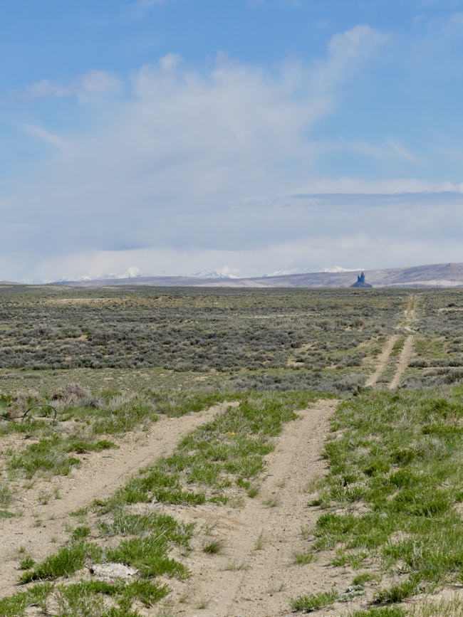
Although remote, there is a parking lot, a long-drop toilet, and a clear trail to the base of the mountain, and a clear trail – straight up.
Although Rock Springs is not as high up as Denver, we are still adjusting to the altitude and the dryness of the air. It is still cold, we are glad of it, because the hike heats us up and we take it at a comfortable pace because the air is so dry and our lips and faces are chapping.
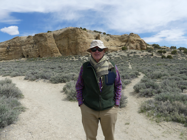
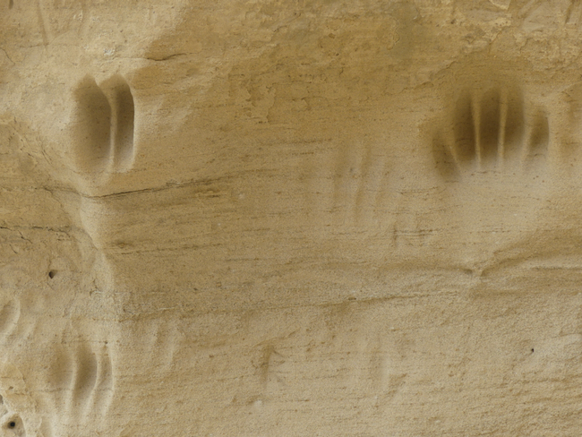
Totally worth the hike. While these are not the best-preserved petroglyphs we’ve ever seen, they are original and intriguing. There is also a lot of modern-day petrographic activity of the high school demographic.

The standard rule with petroglyphs (carved into rock) and petrographs (drawn onto rock) is NO TOUCHING. No rubbing, no outlining with chalk, nothing which might degrade the incision or erode the lines. Someone has used chalk, probably a guide, to help viewers understand what they are seeing. If you know anything about petroglyphs, you know that we can speculate, we can ask modern-day First Nation people, and in the end, it is all speculation. Are they celebrating a triumphal hunt? Are they imploring the spirits to be available for the hunt? Are these incised bear claws a tribute to the bear’s strength? A brag about a bear-clan strength? We can only guess.


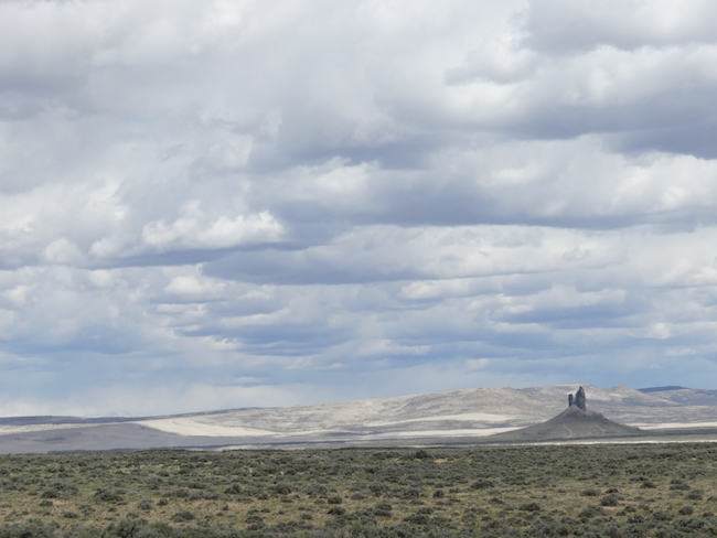
Boars Tusk is the remnant of an ancient volcano thrust 400 feed above the plain; an instantly recognizable landmark for hikers (and people looking for White Mountain.)

We are pumped. We’ve spent a couple hours traipsing around the mountain, seeking out these obscure petroglyphs, trying to decipher what they were meant to communicate. Bottom line – we don’t know, but we are exhilarated and delighted to have found this site.
The county road loops back around to the main road to Farson, and we know that just short of Farson is the Sweet Water Smoke, a barbecue restaurant we’d like to try. We are famished. Hiking and cold fresh air will do that to you!
We find Sweet Water Smoke and are delighted. It is small, and four of the five tables are taken, which leaves one for us. The entire time we were there, people were coming and going, take out orders rolling out the door, this place is humming with activity.
And no wonder! This is not ordinary barbecue! Their cole slaw is Sriracha cole slaw. They offer roasted brussel sprouts as a side, along with more traditional baked beans, macaroni and cheese, etc. I was just blown away to find roasted brussel sprouts as a side in a small Wyoming town. We remember one time traveling through Wyoming when we felt desperate for vegetables and were told to go to this “wonderful restaurant with a salad bar.” The steak was delicious. The salad bar had potato salad, cottage cheese, jello salad, and macaroni salad.
Sweet Water Smoke changes out two additional entrees every week and features a goat-cheese cheesecake with chocolate ganache. Who could resist?


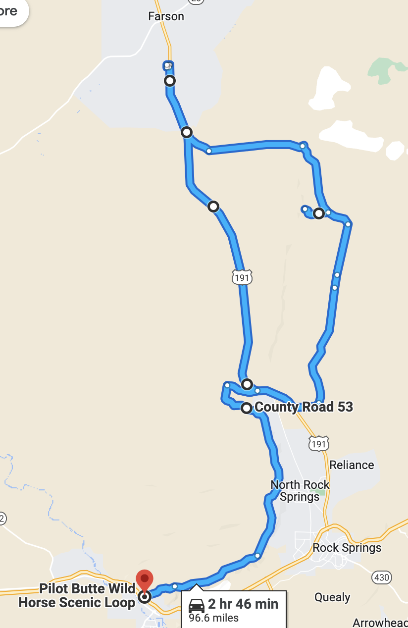
There is a route we want to follow next, the Pilot Butte Road, which is supposed to be challenging, but I think they may have improved the road since we read the warnings because it was easy with our AWD. Having said that, we passed another group busy changing a tire; the road was dirt and gravel and some potholes. Not what we would consider challenging, but a road where we took care.
We were looking for the herds of wild ponies.

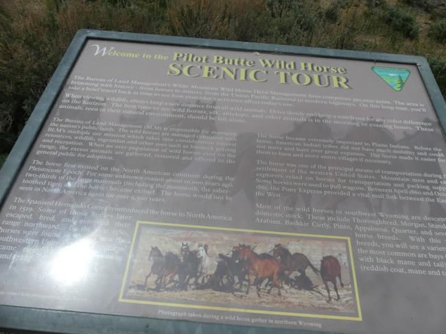


No wild horses in sight, but some mind-blowing expanses of scenery along the track. There were inescapable signs of wild horses, piles and piles of signs of wild horses, but we never saw a single wild horse.

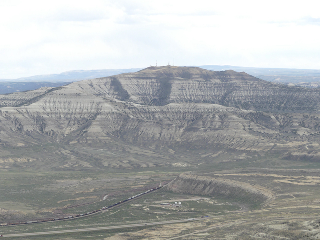
In front of us is a valley where Interstate 80, the old Lincoln Highway, runs. It is also where the Pony Express trail ran before the coast-to-coast railroad took over prompt mail delivery. It makes me sad to see that prompt delivery of mail is no longer a priority for the US Mail system. Here also ran several of the migratory trails as America moved westward. What courage and initiative it took – blasting away hills, bridging canyons and rivers, tunneling through mountains and building across swamps – feats of imagination and engineering. We are in awe of the minds that solved these problems.
Ancient Civilizations Hidden in The Persian Gulf?
I found this first thing this morning on AOL Science News
Theory Points to Civilization Under Persian Gulf
Hugh Collins
Contributor

(Dec. 11) — The waters of the Persian Gulf may be hiding a lost civilization that could change our understanding of human history, according to new research.
This huge fertile stretch of land may have been home to humans from about 74,000 years ago until about 8,000 years ago, according to Discovery News.

When the waters around them began to rise, these early humans may have migrated to what is now the gulf shoreline, founding new settlements there, according to a paper published in the December issue of Current Anthropology.
Wikipedia
New research suggests the waters of the Persian Gulf, depicted here in an historical map of the region, may be hiding a lost civilization that could change our understanding of human history.
Over the past several years, archaeologists have uncovered new evidence of those shoreline settlements.
“Where before there had been but a handful of scattered hunting camps, suddenly, over 60 new archaeological sites appear virtually overnight,” Jeffrey Rose of the University of Birmingham said, according to LiveScience.
“These settlements boast well-built, permanent stone houses, long-distance trade networks, elaborately decorated pottery, domesticated animals, and even evidence for one of the oldest boats in the world,” Rose said.
Rose says such sophisticated settlements couldn’t have developed so quickly, which is why he believes even older settlements lie beneath gulf waters. If true, Rose’s hypothesis could offer a clue as to how and when human beings first departed Africa and settled in the Middle East.
This has long been a topic for debate, with some scientists saying that humans made the migration 125,000 years ago, while others put it closer to 60,000 years ago, LiveScience said.
The now-submerged slice of land would have been about the size of Great Britain, Rose said.
Since it would have received water from the rivers Tigris, Euphrates, Karun and Wadi Baton, it would have offered a fertile refuge from the nearby harsh deserts.
“I think Jeff’s theory is bold and imaginative, and hopefully will shake things up,” Oxford Brookes University’s Robert Carter told LiveScience.
“It would completely rewrite our understanding of the out-of-Africa migration. It is far from proven, but Jeff and others will be developing research programs to test the theory,” Carter said.
Rose admits that much work remains be done. So far, he has focused on archaeological sites on dry land and studies of geological history.
Finding some physical evidence beneath the waves of the ocean would be a major advance in proving that his theory is correct.
“We would need to find a submerged site, and excavate it underwater,” Rose said, according to LiveScience. “This would likely only happen as the culmination of years of survey in carefully selected areas.”
The waters of the Persian Gulf rose 8,000 years ago, perhaps because of the collapse of a huge glacial dam in Canada, according to Postmedia News.
This event caused water levels to rise across the world. This catastrophic event may have forced humans out of the Gulf basin and given rise to ancient stories such as that of Noah’s Ark.
“Certainly, I think there is compelling evidence to suggest that both the flood and Eden myths may be rooted in these events around the Gulf basin,” Rose said, according to Discovery News.
Recent Comments
ExpatAlien on What Country am I Living … intlxpatr on Yellowstone: Old Faithful to C… Michelle on Yellowstone: Old Faithful to C… Cathy on No Grown-Ups in Charge intlxpatr on Waiting for Snow Wikipedia Donate Button

Amazina

Early Voting in Florida


