Dharfur: We can No Longer Pretend We Don’t Know
Today, in his blog, Ogle Earth, which discusses new developments with Google Earth, Stefan Geens says the following about the new hi-res maps of the Sudan made public today in Google Earth:
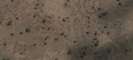
Those circles aren’t animal pens. They’re burned-down gottias, circular mud huts that had straw roofs, and they’re what’s left of Dalia, a village in Sudan’s Darfur region, one of hundreds of villages that have been destroyed by the Janjaweed in a program of depopulation that has killed perhaps 400,000 civilians since 2003.
Today, Google added recent high resolution imagery of Darfur to Google Earth, taken by DigitalGlobe in January-March 2006. It serves as an unequivocal indictment of the Janjaweed, and of the Sudanese government whose implicit support it has enjoyed, because in these new images each and every burned-out gottia is visible. This is the kind of evidence that puts paid to the claims still coming out of Khartoum that the ethnic cleansing is not widespead, and that accusations of genocide are a mere pretext to wrest sovereignty away from Sudan with the deployment of UN peacekeepers.
Read the blog entry for yourself here.
He goes on to say “we can no longer pretend we don’t know.”
He’s right. It’s there, in high resolution, for all to see.
Props to the hard working young man at Google Earth who has been slaving to get all the detailed maps together. It’s a fine mission, ibn uckti, and we are all so proud of you and the hours you put in to make this possible.
4 Comments »
Leave a reply to intlxpatr Cancel reply
Recent Comments
ExpatAlien on What Country am I Living … intlxpatr on Yellowstone: Old Faithful to C… Michelle on Yellowstone: Old Faithful to C… Cathy on No Grown-Ups in Charge intlxpatr on Waiting for Snow Wikipedia Donate Button

Amazina

Early Voting in Florida


How can I help? I am only one person. Where does the need exist? Does someone need to come over there? Bring rice … pick up kids … pray. Please respond. Wanderside
Wanda, I found a wonderful interfaith site that lists the many relief agencies working in Dharfur:
BeliefNet.com
darfur is a very beautiful place
it is so beautiful!!!!!!!!!!!!!!!!!!!!!!!!!!!!!!!!!!!!