Kuwait, al Qaeda Hit List, and Hala February?
Kuwait Times, Monday, February 26, top right front page:
Kuwait on top of Al-Qaeda hit-list
Arab security officials disclosed that a closed door session was held in Iraq between intelligence personnel of a neighboring state and officials of Al-Qaeda in order to execute a threat that was announced by Al-Qaeda recently of attacking Gulf States. The officials warned that Kuwait was on top of their hit-list of states to be attacked, adding that the attack would be executed by Arabs who visit Kuwait with the cooperation of extremist groups existing and operating in Kuwait.
The attackers, they said, would target pivotal and sensitive installations as well as international institutions in Kuwait. Al-Rai daily questioned a senior official on the alleged threat, who confirmed that they had received it, adding that Kuwaiti authorities always take any intelligence reports seriously. He said that the authorities had already executed all security actions to be taken during the last few days in coordination with allied states in addition to scrutinising all visitors arriving in Kuwait.
My comments: Top front page and atrocious reporting.
1. What Arab security officials? Just give us a clue – like from what country?
2. Intelligence personnel of a state neighboring Iraq. . . hmmmm. . . Syria? Iran? Jordan? Kuwait?
3. Which Kuwaiti senior official? From a relevant ministry?
This is supposed to be NEWS. That means there should be verifiable facts. As it stands, it could be just another attack on the bargain hunters at Hala February.
Facets of Oman
At a mountain pottery making village:

The Omani weaver in Jebel Shams:

The Jebal Shams weaver’s grandchildren:

Global Terrorist Incidence Map
My husband told me about a website, Global Incident Map.com where terrorist events are entered on the map and refreshed every 300 seconds (sometimes a little faster and sometimes a little slower.)
You first see a map of the world with flashing incidence icons – explosions, planes, some I am still figuring out. You can click on any one incident to get more information. You can also zoom in and out a la Google Earth – same kinds of controls, to get a closer look at any one part of the globe.
As you scroll down the page, you find a listing of the 25 newest events, listed by country. Scrolling down a little further, you find a search feature, and just below that, events divided into categories (airport/aviation, arson/fire, biological incidents, threats, bomb threats, chemical events, etc.)
The one drawback I have is that every now and then as the maps and incidents refresh, the program hangs up for a matter of seconds to a minute. It clears up faster if you just sit there and do nothing, but I am not good at sitting and doing nothing.
The map is worth a slot on your favorite places list, just for it’s astonishing relevance. Today, for example, in Kuwait, it says:
Kuwait increases security alert
“Officials said authorities did not rule out the prospect that Al Qaida insurgents from Iraq would seek to infiltrate Kuwait and conduct attacks during Hala.”
During HALA????? Strike the desperate bargain and entertainment seekers in Kuwait? We’re that dangerous???
On Wcities.com, HALA is described thus:
“Tourists flock to Kuwait during the period of Hala February. This month-long shopping festival celebrates the beauty of the spring season in the majestic deserts. Whether you come to enjoy the lush springtime greenery and animal life or to purchase items like spices, jewels and ornaments at great discounts, Hala February has it all. The city comes alive with its annual parade, cultural celebrations, entertainment and various organized events. Experience the true, warm Arabian welcome and make your stay a fun-filled experience.”
I don’t think life gets any sweeter than February in Kuwait, but I have a real hard time buying into tourists flocking here for the shopping experience. And a harder time imagining Al Qaeda crazies targeting bargain-crazed shoppers.
Visit to Skyscraper City
As I was preparing to move to Kuwait, and searching the blogs and internet for any information I would find on living conditions, I came across this quirky website called Skyscraper City which has forums on buildings and developments going up all over the world.
My favorite area, of course, is the forum devoted to the Middle East and Africa within which I love to visit Kuwait and Qatar.
Here you find all the latest news, information and GOSSIP about what’s going up, who has applied for permits, and why projects have stalled. It is one of those gems of the internet.
If you want to post, or reply, you have to join the City. There is a Sky Diwaniyya in the Kuwait section that is always entertaining reading.
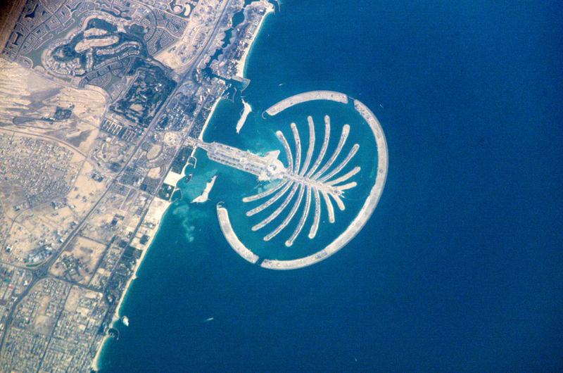
Palm Island Resort, UAE from Skyscraper City Forum
The Pearl in Doha
We’ve been watching the creation of a whole new living area in Doha, the Pearl. Like the palm tree in Bahrain, and similar creations in the UAE, the islands are being created with materials from destroyed buildings, and landfill.
In Qatar, it will be one of two areas where non-Qatteris can buy property, the other being the West Bay Lagoon, near where The Pearl is also being created by the Al Fardan Group.

Sorry for the poor photo quality, but it’s taken through the airplane window. Aargh. It’s interesting seeing where the channels are being dredged for the private boat docks.
Google Earth – Map Your Books!
More news from Earthling (not quite my co-blog writer, but he sure gives me some good stuff to share with you 🙂 )
“This just launched, very cool. Google books search now lets you see a map of all the place mentioned in a book.
Go to books.google.com
Search for your book
Click the ‘about this book’ link.
example: Pride and Prejudice
The 9/11 Commission Report
911 Commission Report
Our Vanishing Wild Life: Its Extermination and Preservation
By William Temple Hornaday
Vanishing Wild Life
The great cities of the ancient world, in their glory and their desolation
By Theodore Alois W. Buckley
Ancient Cities
The Book of Ser Marco Polo
By Marco Polo, Henry Yule, Henri Cordier
Marco Polo
Adventures of Sherlock Holmes
By Arthur Conan Doyle
Sherlock Holmes
Kiss Kiss Bang! Bang!: The Unoffical James Bond 007 Film Companion
By Alan Barnes, Marcus Hearn
James Bond”
Travels of Ibn Batuta AD 1325 – 1354
Ibn Batuta
My comment: The maps usually showed up on the lower right part of the page, not always immediately visible, you have to scroll down. Not every page had a map, but the reference led to other similar books which had maps.
I didn’t even know Google had a book search section – and it is good! When I am reading, I like to read a train of books on the same subject – and I like the way Google gives small summaries which can give you an immediate indication whether this book will interest you or not. Thanks, Earthling!
Publish Your Photos on Google Earth
This is from Earthling, my nephew, who works at GoogleEarth, about contributing to the content layer of GE:
“Okay, it’s not technically Google Earth, and we don’t accept pictures that are too personal, but this can be done. I don’t know if you’ve played with the Panoramio layer in Google Earth (it’s on by default), but if you click the little blue and white circles that look like compasses, up pops a photo someone took. Its a lot of fun browsing these, they are by far the most popular layer we have.
How do you upload your photos? Go to www.panoramio.com and make an account and just start uploading. In order for them to eventually display in Google Earth, you need to give them a location. To do this, start uploading a file, then click the Map this Location button, enter a city name, pick the country/state from a list, and it show you a google map of the location. You can navigate in this just like on Google Maps, and when you find the spot where you took your picture, just double click on it.
The upload time takes a long time… so I don’t know how performance will be. Also, we (Google) don’t display photos of just people anymore. They will simply be removed from the feed panoramio sends Google. The layer is not real time, it gets refreshed every month or so.”
My comment: I uploaded a photo to Panoramio and it didn’t take me much time at all, even with my unreliable QualityNet connection. But just as with WordPress, I downsized the pixels in the photo considerably.
Google Earth Hurts American Forces in Iraq?
This morning on the front page of the Kuwait Times is a story about American forces in Iraq finding GoogleEarth print outs of American bases and strongholds, so clear that those targeting these sites can see the difference between tents and barracks, and can get the exact longitude and latitude for targeting purposes.
Information is always a double edged sword. Information is information, in and of itself, it is neutral. How information is used makes it useful or harmful. And “useful” or “harmful” depends totally on where you stand.
So what do you think? Do you try to censor GoogleEarth when it hurts your side, and oppose censorship when it works to your advantage? Or do you say “hands off” and let the information serve all people equally?
Bahrain Censors Google Earth
This morning my nephew from GE sent me an e-mail with an article from the Financial Times on Mahmoud’s Den and Google Earth in Bahrain. When Google Earth upgraded the resolution on Bahrain, Bahrainis started recording the discrepancy in properties, and circulating copies of residencies, luxury cars, boats, etc. in contrast to the poor, crowded villages. The Bahraini government banned the use of Google Earth in Bahrain. You can guess what happened next – downloads shot through the roof. It’s just human nature.
The article in Financial Times gives more information.
When are governments going to figure out that when you ban a technology, you only make it more attractive? Google Earth downloads for free, it is available to everyone with a computer and adequate bandwidth. No matter what safeguards you put in, there are ways around it. That’s just the nature of technology.
Mahmoud’s Den sports a button that says “No Sunni, No Shiia, Just Bahraini”.
Google Earth – It Just Keeps Getting Better
This morning I had an e-mail from my nephew at GoogleEarth. There are days I feel like one of the luckiest women in the world – my sisters and I have the most interesting children, now young adults, and they are all working in areas where they feel useful – stressed, working too hard – but greatly satisfied, greatly productive.
How cool is it to love Geography, and to be working for GoogleEarth? I grin every time I think of my nephew, who loves the work he is doing.
His e-mail a couple weeks ago reminded me that the new GoogleEarth was out and to be sure to upgrade. You can be sure I did. Today, he tells me about another blog that always has the most up-to-date goodies from GE – Google Earth Blog.
On November 12, Frank Taylor, the blog author, says:
Google has quietly introduced four new Featured Content Layers today. Go to the Layers on the lower left and look for “Featured Content”. Open the folder and look for the new layers at the top. Each is marked with a red “New!”. Here’s a brief overview of the new layers:
Rumsey Historical Maps – This is a collection of historical maps which you can overlay over their location on Earth. If you are not running Google Earth 4, you will not see this layer. Open the folder and turn on the map that interests you. The first link shows you the locations of the different map and each description gives you a few details. You can then turn on each map and they will be overlayed in GE. The maps are “regionated” which means they will load more detail as you get closer (it also means the images are scanned at a very high resolution). I’m sure some of my mapping friends like Jonathan Crowe will be curious to see these.
Tracks4Africa – this is my favorite of the new layers. There are maps of places to go in Africa built by compiling data from GSP tracks. The layer also has lots useful information and photos. Zoom in closer to see more detail. You can read more, and buy the maps for your GPS, by going to Tracks4Africa’s web site.
Spotlight on Africa – This is a collection of placemarks showing the flag of each country of Africa. The placemark description includes an overview of basic information of each country from the CIA World Factbook. The placemarks were developed by the National Geographic My Wonderful World campaign to help kids become more geographically aware. This is nicely done, but you can see the whole world done in a similar fashion in this collection.
European Space Agency – this layer shows ESA logo placemarks of different locations where a satellite photo can be viewed of that location. A small picture is in the placemark description, and a link to a page where you can see a larger picture. I am disappointed that you can’t just view the larger pictures overlayed in Google Earth though.
I am blown away by all the new Africa content. On a day when the sky has turned yellow in Kuwait, there are waves cresting out in the Gulf and the air smells like impending squalls, it is a perfect day to spend in Africa, via Google Earth!
Frank Taylor has all kinds of useful information on GE, and I am adding him to my blogroll.
Recent Comments
intlxpatr on Shampoo Ginger tigerbutterya0c5ff1d… on Shampoo Ginger intlxpatr on British Soldier Kidnapped, Esc… John on British Soldier Kidnapped, Esc… intlxpatr on British Soldier Kidnapped, Esc… Wikipedia Donate Button

Amazina


Early Voting in Florida


